Wow, it's cold out here in the morning. We got up at 7am to get an early start and I could see my breath when I first got outside!
With some additional directions we were finally able to locate Wagner Falls:

As well as the elusive Tannery Falls. The trail starts with a staircase leading into the woods next to the highway ... no wonder we drove right past it last night! It's a nice trail though.

The falls were beautiful too! Just a fine trickle of water dropping 50ft:

After that we headed over to Pictured Rocks National Lakeshore. I fell in love with it after seeing these pictures while planning this trip: Hiking Pictured Rocks. You should check them out -- they're really amazing!
First stop was a short trail to Miners Falls. I love how the early morning light hit the trees and gave them a neon glow.

The falls were incredibly powerful, kicking up spray all the way to the viewing platform. That's why the picture looks a bit foggy.

On the way to Miners Castle I spotted a 0.5mi trail to Miners Lake so I decided to jog down to the lake and take a look. Here's the river:

It wasn't the easiest place to run because of the many exposed roots, mud, and fallen trees to jump over or crawl under, but I finally reached the lake:

I noticed a strange red coloring in the river and the lake. This pictures shows it quite well, although you're probably wondering what you're looking at.

From bottom to top it's: river bank with small plants; river bed; underwater plants; reflection of the trees across the river.
Miners Castle was still mostly in the shade so we decided to return later in the day.
Instead we drove down to Miners Beach. You can see Miners Castle from the side here:

This is where Miners River meets Lake Superior. Can you believe how red the water looks? The water is actually perfectly clear; it's the sediment on the river bed that gives it its orange-red coloring.

One more for good measure:

Both the river and Lake Superior were frigid, but I took off my shoes and went for a walk through the water anyway.

Back to Miners Castle! The shade still hadn't completely left, but it already looked amazing.

Normally you can see the rocks on the bottom, but except for some of the large ones they were hard to see because of the waves. I like how the water here looks almost green.

I love these two little holes at the bottom of the rock. It must go all the way through the rock, because it would spew out water in front after the waves crashed on the back.
Erosion is problem in this area and one of the turrets of Miners Castle collapsed in recent years. I wouldn't be surprised if over time the lake will enlarge this little hole in the rock until it creates an enormous opening ... who knows what will happen them?
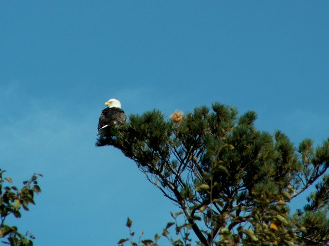
Someone alerted us to this bald eagle sitting atop on of the trees. I'd never seen one in the wild before so it was great to finally find one.
Some of the roads were closed due to construction, so we either had to take a 2 hour detour or do another dirt road. Oh well, at least it was packed gravel and the trees were all shades of reds, yellows and oranges.
We also drove through fields of tree stumps? Not sure what happened there ...

We finally made it to Grand Marais and after filling up on gas we headed east on route 58 to get to the Hurricane River campground. Here the Hurricane River runs into Lake Superior.

I tried to jump from one side to the other to take a better picture, but I twisted my ankle on take off and landed right in the middle instead. My foot was fine, just very very wet!

This stretch of the coast is particularly rocky and the cause of quite a few shipwrecks. You can see several of them on the Au Sable Light Station trail.
There's a mix of (large) boulders and sheets of rock. The water is perfectly clear, but ships would run aground during storms or in the fog.

Here's one of the other wrecks, partially submerged.

We'd walked down a set of stairs to get down to the beach to see the shipwrecks, but we couldn't find another way up until we walked up to the lighthouse. I think this is every little kids dream:

A rope ladder all the way to the top of the hill. Fun, fun, fun! :D
Worth the climb:

We walked back through the woods when suddenly I heard a tell tale sound:

Yes, another snake! That makes 4 for our trip so far ... and you know what, they're really kind of cute.
We stopped at Log Slide Overlook on the way back. At only 0.4mi long this trail has a lot to offer:

Grand Sable Dunes, once the site of a log slide that helped transport trees to boats waiting on the lake. It's 500ft down to the water of which 300ft vertically.
This view in the other direction was nice too with Au Sable lighthouse in the distance:

Cute little guy on the way back to the car:

We ended the day the way we started it; with another waterfall, Sable Falls. Only a short walk from the parking lot, but many many steps to get down to the viewing platform.

Definitely one of the best we've seen!
I love unusual road signs so when we spotted this one we backed around to get a picture:

Caution: cross country-skier crossing ahead!
There was an apple tree right on the edge of the park so we stopped to get an apple:

Once we got to the tree we saw that they all had spots on them. Probably still good for apple sauce and pies, but not for a quick snack. Too bad!
On the way to our next hotel we did see some more fantastic fall foilage:

There are the most brilliant shades of red here. I hope we get those at home, but usually it's more of a yellow-orange color pallette. Here's one more:

We stopped for dinner in the small rundown town of Newberry, also known as the moose capitol of Michigan (not that we saw any). We drove around for a while and just as we were about to have dinner at Pizza Hut we found a local place that looked nice so that's where we ate.
After dinner we crossed back into the Lower Penninsula over the Mackinaw Bridge. Just one more day left :-(
Today's miles: 225


1 comments:
I think this part of your journey is absolutely incredible. Miners River with the red sediment, the bleeched dead trees and white riverbank.
It doesn,t look real, as if somebody couldn,t stop photoshopping. Can,t stop looking at it.
I wonder. Could there be a connection between the field of tree stumps and Log Slide Overlook? haha.
Have a nice day tomorrow and mind the snakes, running around through the bushes!!!
I am looking forward to the next day, the first thing I do in the morning is looking at the blog!!
xxx Love Joeve
Post a Comment